600K CAD to GIS Land Parcel Management
A production-ready CAD-to-GIS workflow that converts fragmented AutoCAD parcel data into structured, searchable GIS data for local government land information management.
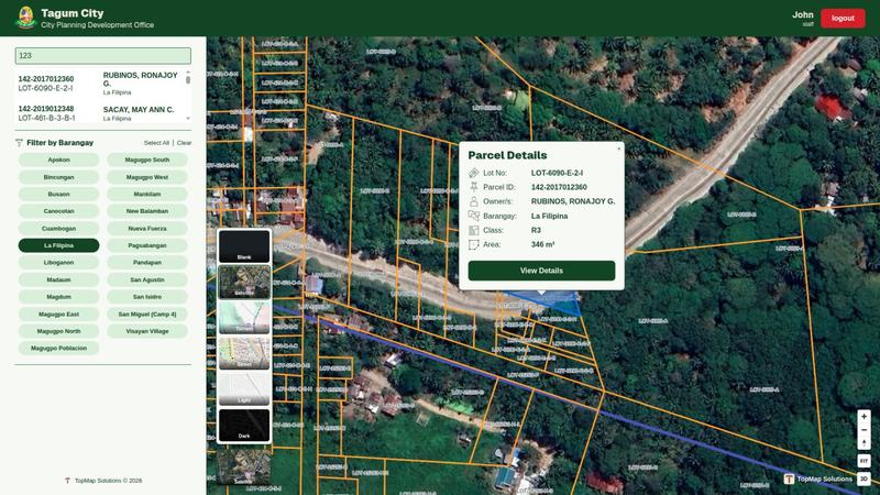
This project is a CAD-to-GIS conversion and land parcel management system developed to address the challenges of working with large collections of fragmented AutoCAD parcel drawings.
The system is designed around a common problem in local government and land-related workflows: parcel information may exist across thousands of CAD files, with inconsistent structure, coordinate systems, drawing formats, and attribute information. Converting this information into usable GIS data can require significant manual processing.
The project explores how this workflow can be automated and transformed into a more structured, searchable, and maintainable GIS system.
The Problem
Traditional CAD-based parcel workflows often require GIS or surveying staff to manually:
- Locate individual CAD drawings
- Inspect drawing contents
- Check coordinate references
- Convert CAD geometry into GIS formats
- Georeference or transform spatial data
- Identify parcel boundaries
- Extract parcel text and attributes
- Organize files by location and version
- Repeatedly perform the same conversion process
When working with thousands of parcels, these repetitive tasks can become a major bottleneck.
The goal of the project was to create a more systematic workflow between CAD data and GIS-based land information.
CAD-to-GIS Workflow
The system establishes a structured pipeline for transforming CAD information into GIS-ready data.
AutoCAD Files → Validation → Coordinate Transformation → Geometry Processing → Parcel Assignment → GIS Database → Web GIS
The workflow handles the conversion and organization of parcel information while preserving the relationship between the original CAD source and the resulting GIS features.
This provides a foundation for maintaining parcel information as structured spatial data rather than relying entirely on individual CAD drawings.
AutoCAD Integration
A major component of the project is the integration with AutoCAD through C#/.NET development.
The custom AutoCAD tools provide utilities for working with parcel drawings and improving common surveying and GIS preparation tasks.
The plugin includes tools for:
- Map and coordinate-system setup
- Parcel inspection
- Geometry checking
- Overlap detection
- Parcel text inspection
- Spatial data preparation
This creates a bridge between the existing CAD workflow used by technical staff and the GIS environment where the resulting information can be managed and analyzed.
GIS & Spatial Data
The converted parcel information is structured as geographic data that can be stored and queried using a spatial database.
The workflow supports coordinate transformation and geometry processing before the information is published to the GIS environment.
This allows parcel data to become:
Accurate → Searchable → Structured → Spatially Queryable
Instead of searching through folders of CAD drawings, users can work with geographic features and associated information through a GIS interface.
Web GIS
The project also extends the CAD-to-GIS workflow into a web-based GIS environment.
The web application provides a centralized way to visualize and interact with parcel information, allowing users to work with spatial data through a browser instead of relying entirely on desktop CAD files.
This creates a workflow where CAD remains part of the technical data-production process while GIS becomes the platform for storage, visualization, querying, and information access.
Parcel Search & Visualization
A further direction of the system is improving how users locate individual parcels.
Parcel information can be searched through associated text or attributes, with the corresponding parcel geometry highlighted on the map.
This transforms a common task from:
Find CAD file → Open drawing → Locate parcel → Inspect geometry
into:
Search parcel → Select result → View location and geometry
The same spatial information can then be used to generate standardized map outputs and other recurring land-information products.
Automation & Data Management
The project focuses heavily on reducing repetitive manual operations.
A structured import and processing workflow allows parcel datasets to be organized by location, year, version, and source information.
This makes it possible to maintain a clearer relationship between:
- Original CAD source
- Processed GIS dataset
- Parcel geometry
- Administrative area
- Data version
- Publication status
The approach provides a foundation for maintaining large parcel datasets as an evolving information system rather than a collection of disconnected files.
Technologies
- C# / .NET — Desktop and AutoCAD tooling
- AutoCAD .NET API — CAD integration and automation
- Django — Backend GIS application
- GeoDjango — Geospatial application development
- PostgreSQL / PostGIS — Spatial database
- MapLibre — Web map visualization
- MVT / Vector Tiles — Efficient web-based spatial data delivery
- Python — Data processing and automation
- GDAL / GIS tooling — Spatial data conversion and processing
Why This Project Exists
The project was built around a practical GIS engineering problem: how to move large amounts of existing CAD land information into a modern GIS workflow without forcing organizations to abandon the CAD processes they already use.
Rather than treating CAD and GIS as separate systems, the project creates a workflow between them.
CAD → Processing → GIS → Web GIS
This allows existing technical workflows to continue producing source data while GIS provides a more structured environment for managing, searching, visualizing, and distributing the resulting information.
Project Outcome
The project demonstrates a complete CAD-to-GIS data pipeline combining desktop automation, spatial data processing, database management, and web GIS.
It shows how fragmented CAD parcel information can be transformed into a structured spatial information system capable of supporting land records, parcel visualization, spatial queries, and future automation.
The broader goal is to reduce repetitive GIS and CAD processing while making land information more accessible and useful for organizations managing large parcel datasets.